Geographic information systems market to register double digit CAGR over 2018-2024, rising product demand for urban planning to augment the industry landscape
Publisher : Fractovia | Published Date : 2018-10-15Request Sample
The global geographic information systems market has recorded a commendable upsurge in the last few years, as the relevance of GIS is expanding, finding not only new application areas but also becoming critical to the area where it is applied. The incorporation of spatial analytics into the offerings that companies provide has become an intuitive part of all forward-thinking organizations that are involved in tapping technology to advance their business functionalities. With geo-enabled capabilities, normal business intelligence can get supercharged and allow a holistic awareness of the situation providing real-time insights into systems and operations. Cloud computing along with IoT devices and apps is enabling the beginning of an instrumented world where companies that are making progress have rightly come to understand the concepts of geospatial solutions. The rising implementation of such systems will thus act as a pivotal driver for GIS market, the valuation of which was pegged at USD 4 billion in 2017.
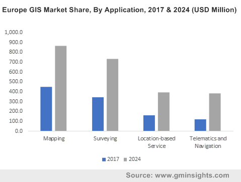
Europe GIS Market Share, By Application, 2017 & 2024 (USD Million)

A revolutionary game changer for the geographic information systems industry is the impressive amounts of geographic information that are being continuously generated by all the organizations in the geospatial community across the globe. In addition, the adoption of Web geographic information systems in the Cloud, the sharing of data openly across all geospatial community and the wider use of maps in all aspects of life will also substantially contribute toward the expansion of the overall geographic information systems market. The range of applications where in geographic information is deployed extensively is indeed diverse and the progressive usage of GIS in these applications is certain to encourage the exponential growth of the geographic information systems industry. GISs have come to be used both analytically and aesthetically across virtually all areas of human endeavor, right from businesses identifying new customers to facilitating response to natural disaster situations.
An instance can be cited in the case of the UN planning a project to set up 17 Sustainable Development Goals across the globe. The UN plans to use geographic information systems to track the progress of each of the goal using a series of 12 to 15 measures and indicators for each goal that communicate the status and progress in each country globally. National statistics and mapping agencies will be collaborating with UN geographic information systems to communicate the status of individual country. As such instances of global usage and success of geographic information systems becomes more common, the potentials of geographic information systems will be unleashed with GIS market gaining significant impetus through such endeavors.
One of the areas that geographic information systems found major application is in urban planning. With the surge of developing smart cities across the globe, geographic information systems market found a new growth avenue as cities are systems of ever evolving complexities that require spatial information for the responsible development of an area which is often updated and robust. GIS is therefore an invaluable tool for urban planners. GIS professionals use spatial data points and spatial thinking for the transformation of data into actionable solutions and insights for improving quality of life and building sustainable communities.
With the help of geospatial data accessed from aerial photography, remote sensors and satellite imaging GIS professionals get a detailed perspective of the land and infrastructure which helps in visualization, modeling and analysis. As urban population continues to expand, GIS becomes crucial in pulling together vast amounts of data necessary for solving problems such as determining the feasibility of a waste disposal site or optimizing new building placement.
In recent times, disruptive changes in technology have vastly impacted the reach of GIS which has continued to expand impressively. Latest computing models such as Cloud, Web and apps of the next generation will affect the GIS ecosystem and subsequent release of upgraded technology is expected to add more capabilities to GIS. While GIS data scientists and analysts will continue to lead the way with groundbreaking progress in spatial modelling and location analysis, creative system architects and software engineers are expected to augment the growth of the GIS market with smart device apps and innovative geospatial solutions.