Aerial imaging market to reap remarkable proceeds from the agricultural application over 2018-2024, APAC to emerge as major revenue pocket
Publisher : Fractovia | Published Date : 2018-06-26Request Sample
With mobile robot technology proliferating every possible industry vertical and causing a paradigm shift, the business landscape of aerial imaging market is set to witness exceptional future growth prospects. Being considered as an essential and cost-effective tool for a myriad of applications, aerial imaging technology has made its presence felt in the range of industrial verticals spanning real estate, military & defense, agriculture, government, and energy & mining operations. On grounds of such a broad application portfolio, experts forecast a rather lucrative blueprint for the worldwide aerial imaging market in the years ahead. Having recently enrolled its name into the billion-dollar fraternity, aerial imaging market for the year 2017 has secured USD 1.7 billion, say reliable reports.
Aerial Imaging Market Size, By Application, 2017 - 2024 (USD Million)
With perpetual technological advancement trends improving the base speed of image processing software, the global aerial imaging market is expected to undeniably evolve at an unprecedented pace. The notable shift, however, is witnessed in the hardware, where advanced sensors and compact technology have made aerial imaging more pronounced and easier than ever before. Aerial imaging has been proving its mettle across wide range of applications and user groups but the one sector that is attracting a plethora of investment trends is agriculture. With the advent of IoT, digitization, and the evolving concept of smart farming, aerial imaging in agriculture is gaining immense popularity and is helping the industry thrive, having been bestowed with the potential to offer data collection & high precision farming.
Thanks to the concept of drones making rapid headways into farming techniques, agriculturalists are adopting aerial imaging into their operation more than ever to cut down on expenses, increase overall efficiency and enhance work safety. Aerial imagery in this discipline has evolved much more than a consumer tool where farmers are able to significantly map different parameters such as soil health, fertility levels, vegetation health, scheduling of irrigation, fertilizers, and pesticides and in-season analysis. Given the numerous benefits, the aerial imaging market demand from agricultural industry is expected to witness high growth in the ensuing years.
APAC to emerge as a lucrative growth ground over 2018-2024
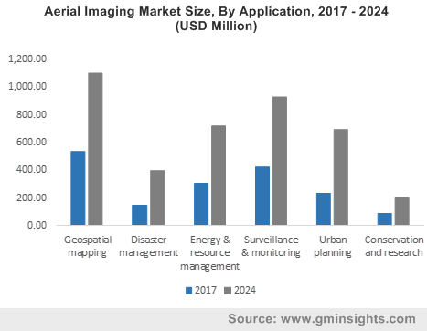
Increasing adoption of aerial photography by government institutions for urban planning and high class infrastructure such as real estate management, road planning, and land use calculations have led to phenomenal growth of APAC aerial imaging industry. By using these aerial images, city planners are able to analyze water features, traffic patterns, buildings, bridges and other infrastructure, in turn making their task efficient with regular up-to-date information.
The use of aerial imaging has also expanded into the region’s agricultural sector and has just begun to exploit its full potential. The advent of low-cost drone platforms has tremendously increased the affordability of UAVs in low-income groups and are therefore gaining traction in the agricultural sector. With large-scale adoption of UAVs for aerial imaging purposes, particularly in countries such as India, China, South Korea, and Japan, the Asia Pacific aerial imaging market is expected to register fastest growth over the coming years. Reports in fact claim the regional aerial imaging industry to register a double-digit CAGR of 16% over 2018-2024.
Attesting to the high growth prospects of aerial imaging industry across the emerging regional landscape, core companies have been adopting numerous market growth strategies in order to strengthen their stance and expand their production capacities. Geographically, most of the manufacturers have already established their ventures in developed countries such as U.S., Canada, Germany, and France, however, the market tactic seems to have strengthened even more in the recent times. Citing a recent instance, IntelinAir has announced its partnership with TerrAvion to deliver the best in class imagery solutions that may help farmers to make data-driven decisions, while improving operational efficiency and ultimately their profitability. The company claims that the strategic partnership with TerrAvion has given it the opportunity to upscale insights & solutions in more geographies.
In addition to such partnership strategies, many industry players are also seen ramping up their positions by setting new benchmarks in terms of product enhancement, performance, and reliability through innovations & technology development. The combination of all these efforts in product innovation and the competitive trends prevalent across this space has led to aerial imaging industry establishing a highly coveted position for itself in the overall electronics sphere. A presumption validating the same is of Global Market Insights, Inc., that claims aerial imaging market to surpass 4 billion by 2024, with a double-digit growth rate.